In an era of rapidly advancing technology, our urban landscapes are constantly evolving. As cities expand, grow, and change, so do the challenges associated with navigating them. Traditional maps and navigation apps have served us well, but emerging technologies like Augmented Reality (AR) and Geospatial Analysis are revolutionizing the way we experience city navigation. This blog explores the fascinating synergy between AR and geospatial analysis and how this combination is enhancing the way we navigate modern cities.
Section 1: Understanding Augmented Reality
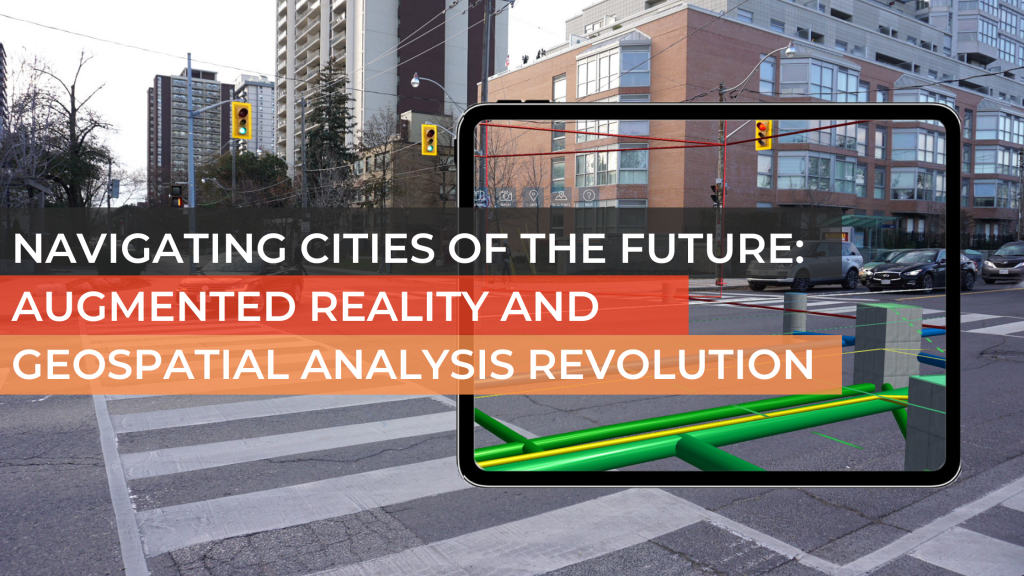
Augmented Reality Defined : Augmented Reality is a technology that overlays digital information, images, or objects onto the real world. It seamlessly merges the digital and physical realms, providing users with an enhanced view of their surroundings. One of the most significant advantages of AR is that it can be experienced through various devices such as smartphones, tablets, AR glasses, and even heads-up displays in cars.
How AR Works : AR technology uses a combination of cameras, sensors, and algorithms to track and identify the user’s surroundings. It superimposes digital content onto the real world based on the user’s perspective. The result is a highly immersive experience that can be used for a variety of purposes.
Applications of Augmented Reality : AR has found applications in numerous fields, from gaming and entertainment to education and healthcare. When it comes to city navigation, it offers a new dimension of exploration, turning the city into an interactive canvas. AR navigation apps like Google Maps and Apple Maps are already in use, providing users with real-time information about their environment.
Section 2: Geospatial Analysis Unveiled
Geospatial Analysis Defined : Geospatial analysis is the process of examining and interpreting data related to a specific location or geographical area. This data can include everything from terrain information and population density to weather patterns and transportation networks. Geospatial analysis allows for the extraction of meaningful insights from this data to make informed decisions.
How Geospatial Analysis Works : Geospatial analysis employs Geographic Information Systems (GIS) to capture, store, manipulate, analyze, and present spatial or geographic data. These systems can integrate various data sources, such as satellite imagery, GPS coordinates, and digital maps, to provide a comprehensive view of a location.
Applications of Geospatial Analysis : Geospatial analysis is widely used in urban planning, disaster management, agriculture, and environmental science. In city navigation, it plays a critical role in helping us understand the dynamics of a city and make data-driven decisions for improving transportation, infrastructure, and public services.
Section 3: The Fusion of AR and Geospatial Analysis
AR and Geospatial Analysis: A Perfect Match : The combination of AR and geospatial analysis is a natural synergy, as both technologies enhance our understanding of the physical world. When fused together, they have the potential to revolutionize city navigation. Here’s how:
- Real-time Data Overlays: With AR, users can access real-time geospatial data, such as live traffic updates, weather conditions, and nearby points of interest, superimposed on their view of the city. This information can significantly improve route planning and decision-making.
- 3D Mapping: AR can create immersive 3D city maps that help users orient themselves in complex urban environments. By integrating geospatial data, these maps can display detailed terrain, building information, and infrastructure, aiding navigation.
- Location-Based Services: AR can provide context-aware information. For example, by recognizing a building or landmark, an AR app can offer historical details or user-generated reviews, enhancing the city exploration experience.
- Personalized Navigation: Geospatial analysis can generate personalized navigation routes based on user preferences, traffic patterns, and historical data. AR can then provide turn-by-turn directions and real-time adjustments to the route.
Use Cases of AR and Geospatial Analysis Integration
- Tourism and Travel: Tourists can use AR-enabled city guides that combine geospatial data to offer rich information about historical sites, museums, restaurants, and local culture.
- Public Transportation: AR can revolutionize public transportation. Commuters can use AR apps to receive real-time updates on bus and train schedules, platform changes, and even identify the nearest bus stop or station.
- Emergency Response: First responders can benefit from AR overlays of geospatial data during crises, aiding in search and rescue missions and disaster management.
- Urban Planning: City planners can utilize AR and geospatial analysis to visualize and simulate proposed infrastructure changes and understand the potential impact on the cityscape.
Section 4: Challenges and Future Prospects
Challenges: Despite the potential of AR and geospatial analysis in city navigation, several challenges must be addressed:
- Privacy Concerns: Collecting and sharing location-based data raises privacy issues. Users may be uncomfortable with the extent of data collection required for personalized navigation.
- AR Adoption: Wider adoption of AR glasses or headsets is needed for a seamless AR navigation experience. Currently, most users rely on smartphones, which can be distracting when used for navigation.
- Data Accuracy: Geospatial data must be accurate and up-to-date for reliable navigation. Outdated information can lead to navigation errors and frustrations.
Future Prospects : The future of city navigation is promising with AR and geospatial analysis at the forefront:
- Wearable AR Devices: As AR glasses and headsets become more commonplace, users will have a hands-free, heads-up navigation experience.
- Smart Cities: The integration of AR and geospatial analysis can be a cornerstone of smart city development, providing real-time information to improve urban living.
- AI-Powered Navigation: Machine learning and AI will play a larger role in personalized navigation, making route recommendations even more accurate.
- Sustainable Transportation: AR and geospatial analysis can promote sustainable transportation choices by providing information on eco-friendly transit options.
Conclusion
The fusion of Augmented Reality and Geospatial Analysis is transforming the way we navigate our cities. This dynamic duo offers an array of applications that enhance our understanding of urban environments and make city exploration more immersive, informative, and personalized. While challenges remain, the future prospects of this technology combination are exciting. As AR glasses become more prevalent, smart cities continue to evolve, and AI improves navigation, the urban landscape will be more accessible and enjoyable than ever before.
Whether you’re a tourist, commuter, or city planner, the collaboration of AR and geospatial analysis promises to make city navigation a thrilling adventure into the future.
Tags: #ARVR, #BigData, #MachineLearning, #SmartCities, #DataAnalytics,
#PredictiveAnalytics, #UrbanDevelopment, #CityPlanning, #UrbanPlanning,
#UrbanInnovation, Geospatial Analysis